Author: admin
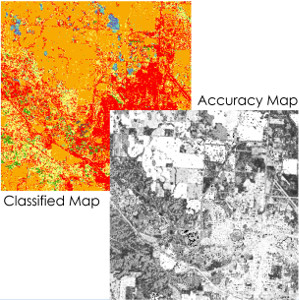
Creation of pixel-based accuracy maps for RS classification
Detailed accuracy maps communicate effectively limitations of RS classification products. Using interpolation methods in the spectral space we demonstrate that per-pixel accuracy predictions are feasible and they offer a better representation of accuracy variability in a given scene. Further information: R. Khatami, G. Mountrakis, S. Stehman (2017). Mapping per-pixel predicted […]
Read More
High urban land consumption linked to lower African American population, higher poverty rate and lower income per capita
Study used satellite data to look at developed land consumption across the continental US. Distinct geographic patterns were identified in terms of developed land consumption per capita. Of particular interest is the that high developed land consumption counties have statistically lower Black/African American population, higher poverty rate and lower income […]
Read More
Forest attrition is higher in the Western US, in public and rural lands
Analysis of satellite data in the 1990s identified that the average distance to forest in the continental US increased by 14% during the 1990s. Further landscape grouping identified higher forest attrition in the Western US and in public and rural lands. Further information:S. Yang, G. Mountrakis (2017). Forest dynamics in […]
Read MoreNews
Top15 News Highlights 2017. Feb: NY Times and Washington Post covered our forest attrition work. 2015. May: SUNY ESF Exemplary Researcher Award Announcement 2015. Jan: New grant from NASA to study Grazing Systems in the Altai Mountain Transboundary Zone. 2015. Jan: Associate Editor for the ISPRS journal. 2014. Mar: New […]
Read More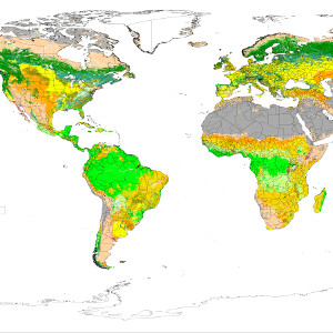
Review of global and regional land cover products
Proliferation of satellite data has resulted in a wide range of large scale land cover products. In this review we discuss characteristics of 21 global and 43 regional land cover products. Further information: G. Grekousis, G. Mountrakis, M. Kavouras (2015). An overview of 21 global and 43 regional land cover […]
Read MoreMedia
Forest attrition study (original paper here) New York Times: How Far to the Next Forest? A New Way to Measure Deforestation Washington Post: Americans once moved away from forests. Now forests are moving away from Americans Phys.org: Farther from forest: ‘Eye-opening’ study says rural US loses forests faster than cities […]
Read MoreNASA Land Cover Land Use Change PhD Position
The Intelligent Geocomputing Lab at State University of New York College of Environmental Science and Forestry (SUNY ESF) is looking for Ph.D. student to lead remote sensing analysis in an interdisciplinary grant funded by NASA. We will study rangeland conditions of the Altai Mountains in central Asia and identify linkages […]
Read MoreCV
Giorgos Mountrakis, PhD Professor, Dept. of Environmental Resources Engineering State University of New York College of Environmental Science and Forestry Full CV: Available here. Short Biography: Dr. Giorgos Mountrakis is a Professor in Environmental Resources Engineering at the State University of New York College of Environmental Science and Forestry. He […]
Read MoreGrants
Research grants (in chronological order): Cumulative award amount as lead PI or Co-PI: $3.8M, As lead PI: $3.4M. “A decision-making activity to guide archipelago-wide rewilding of Galapagos giant tortoises” National Aeronautics and Space Administration, Ecological Forecasting Program Role: Lead PI with James Gibbs, Amount: $797,000 , Duration: 2021-2025. “Developing novel […]
Read More