Month: July 2009
GIS and Remote Sensing Journal List with Impact Factors
GIS and Remote Sensing Journal List with Impact Factors The following list provides impact factors for relevant GIS and Remote Sensing scientific journals. 2013 Impact Factor , (5-year Impact Factor for 2013 , 5-year Impact Factor for 2011) Journal Name ** Remote Sensing 4.77 (6.07, 5.28) Remote Sensing of Environment 2.90 […]
Read MoreUsing LIDAR to assess the roles of climate and land-cover dynamics in biodiversity changes
Collaborators: Dr. Giorgos Mountrakis, Dr. Bill Porter, Dr. Colin Beier, Dr. Ben Zuckerberg, Dr. Lianjun Zhang, Dr. Bryan Blair Funders: NASA Biodiversity Program Motivation: Recent work has demonstrated a northern shift in bird habitats over the past 20 years in NY State. Our motivating question is to assess whether this […]
Read MoreA GIS-based urban growth model for Denver, Colorado
Collaborators: Dr. Giorgos Mountrakis, Jida Wang, Dr. Dimitrios Triantakonstantis Funders: NSF, NASA, SUNY ESF Graduate Assistantship Motivation: Urbanization is an important issue concerning scientists from different disciplines such as urban planners, biologists, engineers and is also extensively considered by policy-makers. A computational model quantifying locations and quantities of urban growth […]
Read MoreA multi-scale radial basis function neural network
Collaborators: Dr. Giorgos Mountrakis Funders: University of Maine covered patent application fees. Motivation: One of the constraints of radial basis function (RBF) neural networks revolves around the ability to combine local functions of variable spreads. Development of a multi-scale RBF would allow RBFs to exhibit their full potential in regression […]
Read MoreSatellite image classification by integrating multiple AI methods
Collaborators: Dr. Giorgos Mountrakis, Lori Luo, Dr. R. Watts Funders: Multiple sources. Motivation: Remote sensing as a field of study has reached its adulthood; computer-assisted classifiers have been in development for more than two decades. The complexity of remote sensing classification has led to a variety of methods, some of […]
Read More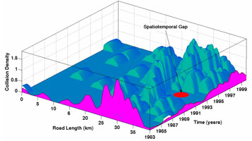
Spatiotemporal analysis on animal-vehicle collisions
Collaborators: Dr. Giorgos Mountrakis, Kari Gunson Funders: Humane Society, SUNY ESF Graduate Assistantship Motivation: Moose-vehicle collisions (MVCs) pose a serious safety and environmental concern in many regions of Europe and North America. For example, in the state of Vermont one-third of all reported MVCs resulted in motorist injury or fatality […]
Read More